The Stelvio Pass is the best road in the world.
The Tail of the Dragon is the best road in the world.
The Col de Turini is the best road in the world.
You can waste time arguing about the world’s best stretch of pavement. This is the story of the second-best road. Sure, Israel’s Negev desert is a little out of the way. Sure, it might just run alongside a nuclear facility. But the scenery is resplendent, and Routes 225 and 227 are worth the effort.
The two roadways comprise a challenging circuit, one car wide and about 30 miles long, which function simultaneously as dual-carriageway and rally stage. Blind curves and dips in the road appear as frequently as wayward dromedaries. You won’t find this ride in any guide books.
To do the drive properly, start in a metropolitan environment and leave hastily. To that end, wake up at Tel Aviv’s Hotel Montefiore. Tucked away on a narrow street in the city that prides itself on endless sunshine, the Hotel Montefiore is a seductive oasis devoted to the chiaroscuro. Located far off the Miami-grade cluster of beach hotels lining the city’s coastline, the hotel remains an exclusive secret. Its tryst-at-a-library guest room motif encourages mental stimulation and exploration, from the paperback thrillers that line wall-length shelves to the magnifying glass and notebook in the bedside dresser drawer.

In the morning, sip a cappuccino on the balcony, map in hand, and dedicate the rest of the day to driving. Take a stab at rental car roulette. Leaving Tel Aviv is simple as a nine-minute hustle through the city to the Ayalon South, a highway resembling California’s 405 in width and rush-hour congestion. The 20 becomes the 1, becomes the 4, becomes the 7. Pick up Highway 6, about 35 minutes into the journey, and take it until it ends, as the 40, in the city of Beersheva. (If that seems confusing, fear not: the signage is in English, Hebrew, and Arabic.) The route is lush and agrarian until you reach the city. Have another cappuccino with lunch at the Bedouin market, before finally heading to the roads that matter.
Urban life disappears once you depart Beersheva, following Route 40 to the newly repaved Route 224 toward the town of Yeruham. Public buses struggle to ascend Route 224’s hills. Yeruham appears, finally, as a cluster of shrubs and concrete buildings.
Finding Route 225 is a challenge in itself. The road begins in earnest at the eastern edge of Yeruham, just past a glass factory. Follow the street as the scenery turns desolate. A sign warns of “DANNGEROUS CURVES.” The road, which is supposed to offer two lanes, is only wide enough for one-and-a-half cars.

You’ll wonder if this road was worth the hours of travel. Then, you’ll get the sense that something unadvertised is coming. The road narrows, elevation drops. A sweeping S-curve appears. Ginger application of the brakes is a smart move, ahead of a set of decreasing-radius hairpin curves, which follow the rocky contours. The next corner begins to reveal the Large Makhtesh. It’s a sight as awe-inspiring as the Grand Canyon. (The Small Makhtesh isn’t far away, as is the Makhtesh Ramon.)
Just before dusk, the residual sunlight daubs the entire canyon, highlighting its peaks and valleys in atomic tangerine. The whole road, and the makhtesh itself, are in full view. There are no devoted spots for pausing. Do it anyway. Then, blast down the completely straight hill. Let engine braking do the work. Another sign appears, advising caution around camels.


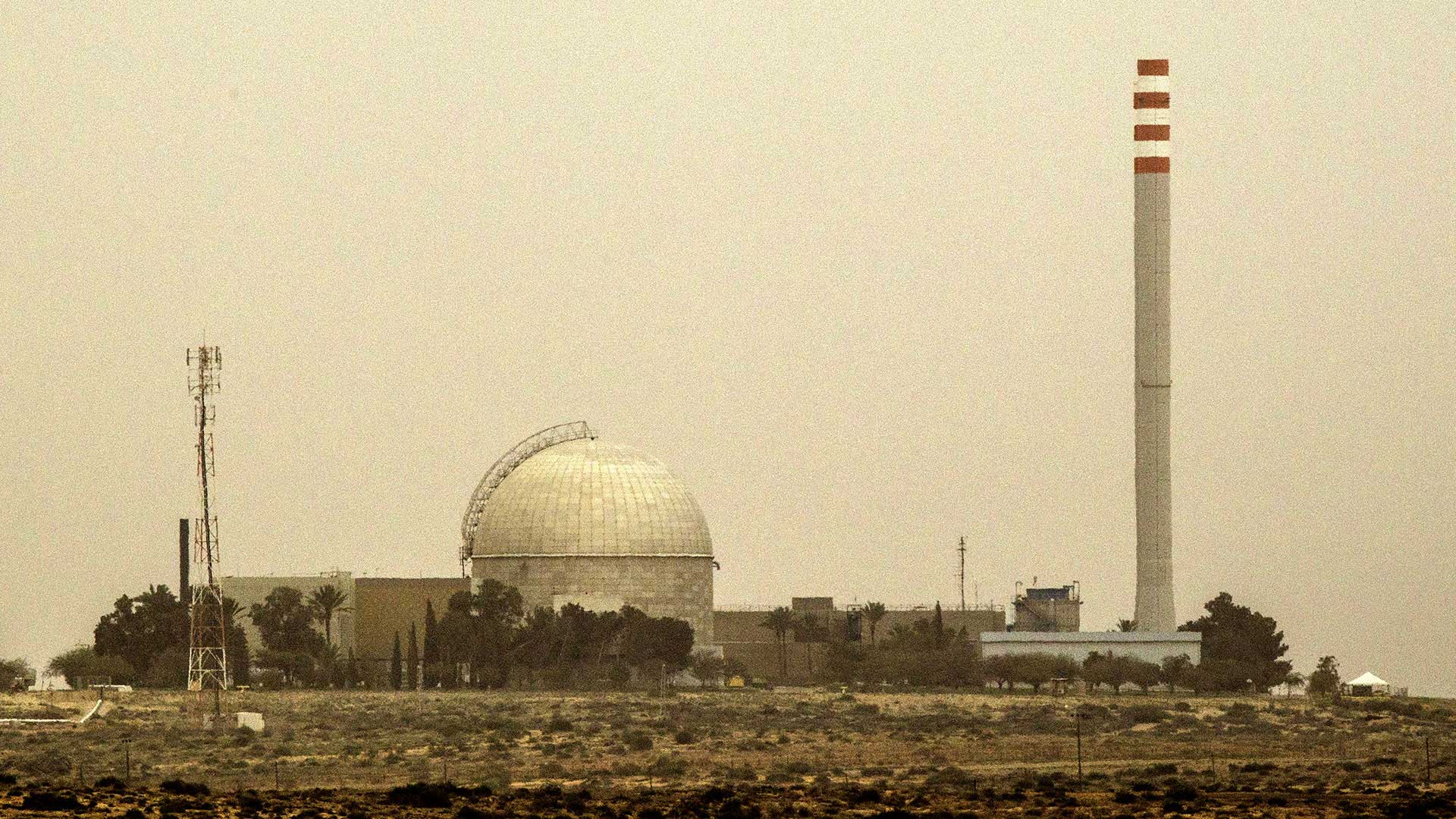
Pass the Colored Dunes—a sandy oasis where elementary school children fill up plastic bottles in pink, blue, and yellow layers of the stuff—and make a left onto Route 206. At this point, the road ahead mimics the flat and unending stretches of pavement in the American West, replete with truckers and cacti. To the left are sandy hillocks and mounds, dotted with “NO PHOTOGRAPHY” signs. To the right, through the Schlieren lines, is a shimmering tower, shaped like an observatory. It’s a poorly kept secret that Israel’s nuclear reactor is located near the city of Dimona, right off Route 225. The locals might tell you that it’s a textile factory. Heed the photography warning—and don’t stop.
Inevitably, if you arrived to see the sunset, you will undertake the final leg of the journey—toward Dimona’s burgeoning city center or deeper into the desert—in the dark. Head toward Dimona for a local beer from Negev Brewery. After all that driving, you’ll have racked up nearly 175 miles.

The great driving doesn’t end there. At the end of the road, take a right, and follow Route 25 to the Arava Junction to refuel. Route 90 runs south to meet Route 227, a stimulating road in its own right. In this direction, it’s an uphill run called “snake road,” as its sharp curves ascend back up toward the top of the canyon. It’s the type of road that you want to run all day, knowing that it’ll be a long time before you return.
—
DRIVE… Anything.
A Jaguar F-type V6 S or Mercedes-AMG C63 S each possess the tossability for unexpected corners and the outright fury to flood the entire makhtesh. Alternatively, you can rent the first available car. A Nissan Micra will more than suffice.
STAY… Hotel Montefiore.
36 Montefiore Street, Tel Aviv, Israel (+972-3-5646100 / hotelmontefiore.co.il)
EAT… Little India.
15 Ringelbloom Street, Beer Sheva, Israel (+972-8-6489801)