An Ode to the Loneliest Highways
Two-lane blacktop is still the best way to get around, if you can make time for it.

After driving across the country without stopping – as I did with a handful of other Cannonball nerds last month – there's a need to unwind. No matter how fast or slow you go, 40 hours spent driving across the continent without pausing to smell the roses is an intense experience. When you've done it and you need to come back the other way just to get home, the thought of repeating this sort of motoring onslaught is enough to send you off into the night; running, screaming, tearing out your hair, likely with a trickle of mind-numbing spirits dribbling down your chin.
There's a cure for that malady, and for the speed modern life demands: More roads. Only this time, not the freeway. A trip that lingers in places stark and lonely. The sorts of roads that seldom, if ever, thread among strip malls and industrial parks. These are the byways that most Americans have forgotten in their hurry to Get There on America's convenient network of interstate highways.
I can no longer count how many times I've driven across America, but three of these odysseys have been of the nonstop, bragging rights variety. And, like most Americans, I seldom leave enough time to do the cross-country drive justice. Not when I moved east from California to New York; not when I moved west to Colorado and not even when I moved back east again.
But this time was different. I had my wife with me, and like many sensible wives around the world, mine isn't into staring at a windshield for hours on end, just to say that she did. So we plotted our route across the American West on two-lane blacktop.
To understand where this very human longing for open space originates, let me share a slice of my past. Maybe you can relate. Growing up in the Northern Virginia suburbs – one of those ubiquitous American bedroom communities – I had a sense that there simply had to be places, somewhere, that weren't designed (if they were even designed at all) mainly to sell more and more things. The unincorporated housing tracts outside Herndon – a rural whistlestop-cum-tech hub – were, and are, comfortable as far as living standards go. The houses were roomy, the neighborhoods were relatively safe, there were communal outdoor pools and there were woods in which we kids could bash around and allow our imaginations to run wild.
But there was a subtle oppression to the structured part of the place, perhaps stemming from the fact that construction, or plans for construction, presented themselves in every corner. If you saw, for example, a small white frame house with an inviting front porch perched along the entry to a bucolic gravel lane one year, both might be gone the next – victims of main road widening and rural road paving, respectively. Your favorite clump of trees probably wouldn't survive the advance of strip mall and housing development construction. Traffic-choked roads snaked in every direction.
My juvenile peers and I had our own highway system – the rank footpaths that meandered through the oak forest at the edge of the development. Those trails eventually fell prey to the organizing influence of The Pavers, too. Walking across concrete "stepping stones" evenly spaced across a concrete stream apron isn't quite the same as tiptoeing across slimy rocks or a moss-covered log. There's no danger; there's no challenge. The excitement of it (and trust me when I say there can be excitement – I watched my mother topple five feet from a log into a shallow creek bed during a Cub Scouts den walk) gives it flavor and realness. The jagged edges of nature are more pleasing than the orderly cube shapes of the office park that replaces it.
When I reached driving age, I had already spent years exploring new routes around my corner of Fairfax County on a mountain bike. Always on the lookout for the physical embodiment of Robert Frost's imagery in "The Road Not Taken," it was always rewarding to find a new gems in the woods – little-used dirt trails, stream tunnels or, best yet, abandoned, overgrown structures. Unwelcome as they were initially, I made use of the asphalt-paved recreation trails as they became available. Like the four-wheeling enthusiast who drives far away to enjoy some new, unexplored pocket of mud or rock, I was able to get farther afield with the advent of modern road surfaces to my small-scale, pedal-powered world. The double-edge sword of progress had been wielded.
As the years whizzed by, remoteness became more difficult to locate. The dairy farm I used to cut through to get to Herndon's old town had been a magic portal from the suburban reality in which I lived to a yesterworld that had weathered lifetimes without changing much. Like so many properties of its kind, its owners were unable to resist the pressure of development money, and it was sold and subdivided. The laid-back, friendly disorder that characterized the farm is gone. Today, that insular patch of simplicity has been replaced by a stark row of large, cube-shaped brick colonials. The dirt and gravel track that once connected the farm to the main road now assumes the gentle curve of a concrete-curbed cul-de-sac, replete with a "Drive Like Your Kids Play Here" sign. A branch of the creek that had run along the edge of the farm has been converted into a forbidding drainage basin. The new residents seem content, but they're also unaware of what was lost.
The car my grandfather gave me when I was a senior in high school – a rusty maroon '83 Corolla wagon – extended my range to parts of the region that had not yet been transformed from tousled rustic charm into vinyl-sided, concrete-lipped order. (Those places have since fallen to the axe, too, as The Nothing has pressed westward in search of more space to consume.) An ADC map book (this was 1996, before most people had GPS) was one of the first post-licensure Christmas gifts my parents gave to me. I made use of it to find routes to places that diverged from the well-traveled paths relied upon by most other people in the interest of reaching destinations in the shortest amount of time possible.
By the time I reached my third year in college, the Corolla had long since been sent to the crusher (after I'd wrecked it) and I'd inherited my dad's rusty old '83 Camry hatchback. With its relatively large size, easy highway manners and solid fuel economy, it was the perfect roadtripping car. "Don't drive it faster than 60 miles per hour and it will last longer," advised my dad, who had already driven it to 238,000 miles. So I had even more reason to keep to the smaller, slower roads.
The next years were a blur of new places. Virginia's scenic byways had never found so dedicated a customer, or so I thought at the time. Fredericksburg to Virginia Beach – the Tidewater Trail through Gloucester Point, across the Coleman swing bridge (to myself, I'd call it the Gary Coleman bridge and say, 'Whatchyu talkin' 'bout, Willis?' as I crossed it) into Yorktown. Charlottesville to Fredericksburg – state route 20 past the Barboursville ruins and two early presidents' homes, into the Wilderness battlefield. Occoquan to Herndon – state route 123 past Prison View Estate, a small home next to D.C.'s correctional facility, which was then still housing inmates. Wherever I went, I looked for a byway, or a road that hadn't yet been disturbed by progress.
What I saw varied with each route. Unlike the interchangeable commerce nodes you encounter on even the most desolate stretches of interstate – the ones with McDonald's and Subway and Love's travel plazas – life along these routes bore reminders that human beings can, in fact, be different from one another in subtle ways. One used car lot might have a preponderance of grandmotherly Buicks and Oldsmobiles. Another town might boast a monster truck with a for-sale sign stuck inside its windshield. Old men piloted riding mowers across neat lawns in front of their neat ranch homes. Decorative plastic flowers spun in the breeze. Gas stations advertised egg sandwiches, and sales on beer and cigarettes. Churches admonished passing motorists to take the Lord Jesus into their lives. Men in suits walked in and out of brick courthouses and young couples in pickup trucks drove through town with babies perched between them on bench seats.
This may all sound vague and unimportant, and perhaps it is. But these various, momentary facets of life wove rich threads into each trip's experiential tapestry. I was looking at a living portrait of the human-scale America that had ceased to exist where I grew up. Life had slowed down, and was no longer a blur of appointments to be met.
Fast-forward to this fall. I'd just completed this fast-paced journey across the country on interstate highways. The pressure of getting there without wasting time kept me focused on driving. There was some scenery, some of it beautiful, but enjoyment of it was cursory, like eating small crumbs of brown sugar from an otherwise bland slurry of unbuttered oatmeal. The trip back had to be better.
To begin with, our journey took us north, from Los Angeles toward Santa Barbara, then north and west through the Santa Ynez Valley into San Luis Obispo. California's landscape is memorable in its beauty, but this time, its most stunning feature was how dry it was. The drought is real enough to any East Coaster, but the bristle dry grass and the brown-ness of trees that were usually dark green made it seem like a place that would never again support life. The same unseasonable heat wave that beat upon the coast parched the Central Valley to a greater degree. Signs were planted next to rows of dead orchard trees, but the only seed they could grow was discontent with government officials.
"No water = no jobs! Stop politicians created water crisis! Congress created dust bowl!" the signs read.
Perhaps politicians had everything to do with California's water supply issues, but reading a few chapters of Marc Reisner's Cadillac Desert is enough to make anyone realize that most of the culpability goes to lawmakers who set up irrigation farming in the region a century or more ago.
My wife and I wilted in our seats and watched the car's temperature gauge climb a bit as we drove across mile after mile of dehydrated farmland. The air temp topped 95 degrees. At last, steely gray (as opposed to dusty brown) mountains appeared on the horizon, and the first dark strands of coniferous trees heralded our climactic salvation. The temperature fell and our spirits rose.
Yosemite National Park is a peculiar example of natural beauty. A small highway takes you on a rollercoaster ride through the foothills and mountains leading into the Merced River valley. Yosemite Valley, as it's called, is where all the action is. This is the place you've seen on post cards and tourism posters. The sheer granite walls that have for decades inspired climbers to conquer them stand silently on either side of a chain of sunny, peaceful aspen meadows. The hotels, restaurants and traffic seemed at odds with the natural beauty of the place, but the road that brought hordes of pasty-legged tourists from all over had also made it possible for us to enjoy a single day of Yosemite's natural splendor.
Although Yosemite National Park covers nearly 1,200 square miles, most of the park's 4 million annual visitors congregate in Yosemite Valley – the place with all the restaurants and hotels. Among the crowd, we managed to find the place where the people weren't. As I had growing up in the suburbs, I spotted an overgrown track through some dry grass and started walking. Before long, the hiss of tires on pavement disappeared, and all I could hear was the whisper of a light breeze through the aspen leaves. The Merced River coiled across the meadow, and we found a deep swimming hole on one of its bends. Behind our swimming hole, above an embankment, cars lined up along one of the main roads. But the dirt path I'd found had led us into a forgotten void between Yosemite Valley's two thoroughfares.
If you've never driven through the Tioga Pass, I recommend it. You leave Yosemite Valley, climbing a steep road into Tuolomne Meadows. Pine forest fades into stark rock and towering peaks flank the threadlike roadway. As we crested the apogee of the pass, the cloudless sky seemed hollow – it was placid, but with a menacing promise of destruction should storm clouds suddenly appear. On our descent toward the east, the landscape opened up again as the stone towers receded into the rearview mirror. The distant sheen of Mono Lake appeared on the plain below.
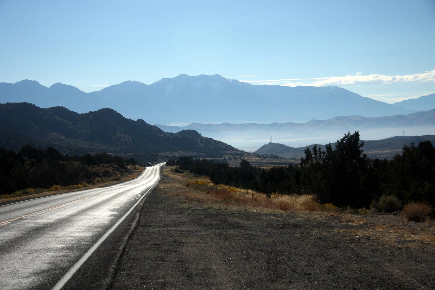
As we got closer to it, Mono Lake loomed, majestic and still beneath the glare of the desert sun. Its motionless salt pillars were like white uniformed security guards in a place no one would ever rob. We stopped at a small visitor center near the highway and drank in a panoramic view of the lake, absorbing pervasive silence. The pause was brief, and after fighting through some construction delays on the road leading to Reno, I pointed the car east on state route 167, escaping civilization along the northern shore of the lake. I took a deep breath, inhaling warm, dry air that smelled like desert flowers. This was where the real journey began.
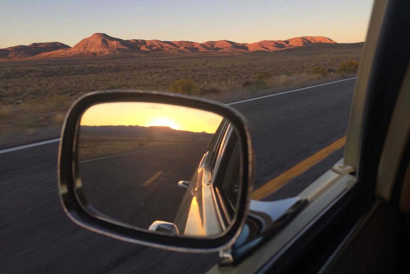
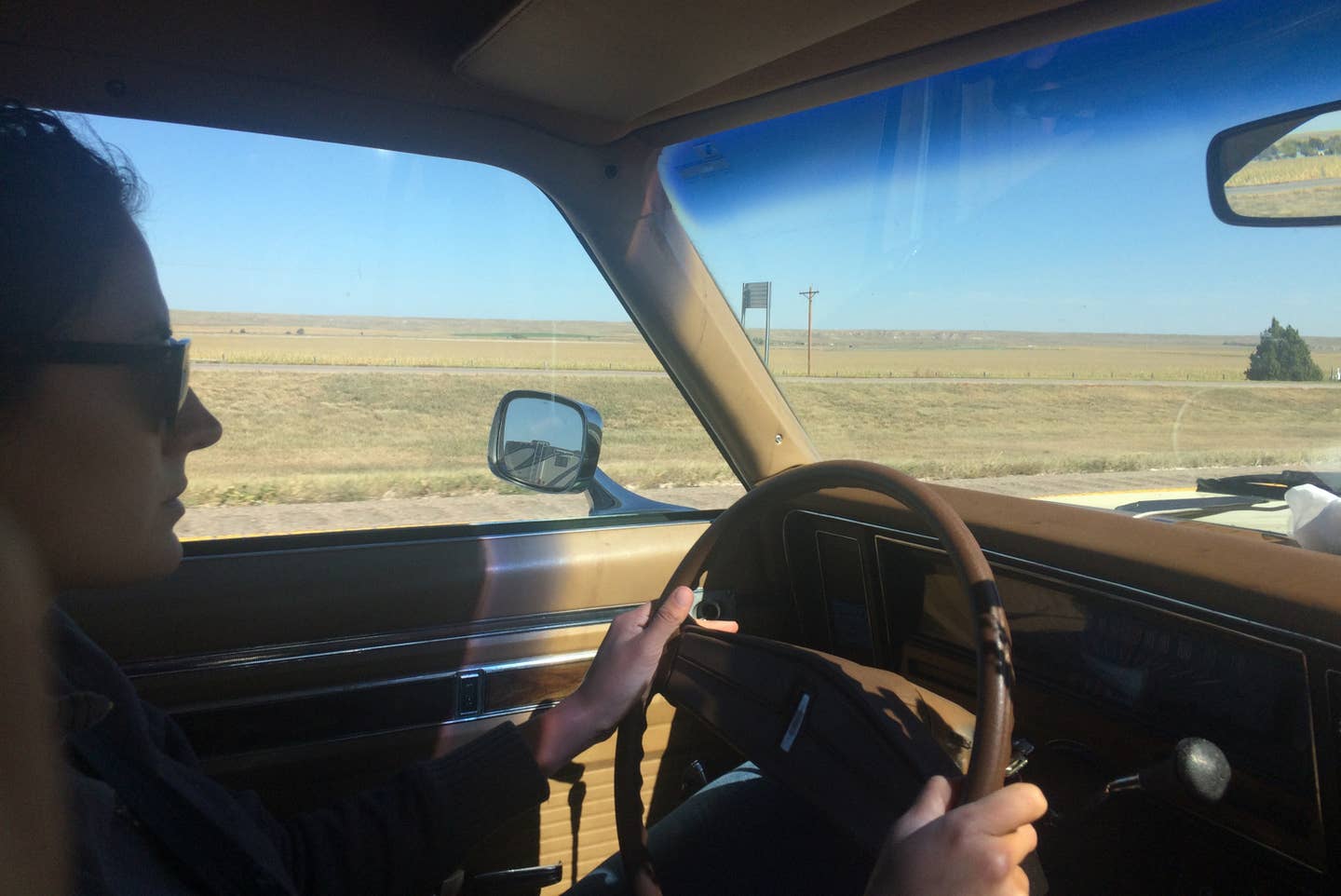
Driving through the desert on roads like this is a solid reminder of what it's like to be alone. Granted, I was with my wife, but we were an island unto ourselves. When we stopped, to stretch our legs or to take in a view somewhere, other cars and trucks seldom appeared. We were able to stand in the middle of the road and stare up at the sky without fear of peril from fast-moving machines. You could see them coming from miles away. Out here, there was only space.
Across eastern California, Nevada, Utah, northern Colorado and southern Wyoming, we settled into a pattern: speed across colossal plateau, climb and descend gigantic mountain range, repeat. The plains between mountain ranges each had subtle differences in vegetation, and in the color of the mountains. Occasionally, we passed through a small town. There was a mining town here, an agricultural community there. Groups of shrieking children frolicked on schoolyards in parts of the country that were otherwise devoid of human inhabitants. Other than the asphalt ribbon, there wasn't much evidence of human involvement between settlements. Here and there, we passed (and sometimes stopped at) primitive rest stops, most often built by an Eagle Scout as his service project.
One thing that was constant throughout the trip was the presence of really wild-looking tire marks on the road surface. Most swerved off the side of the road, but some created a wave pattern before turning around completely. Others defied reason. How had these marks occurred? I had to wonder how many of them had been the result of drivers falling asleep at the wheel. I hoped no one had been hurt, only jolted awake by the violence of a near-death experience. Then again, some of these tracks had the potential to have been made by someone with nothing better to do. I thought back to my own vacant road automotive experiments – 60 mph 180s, donuts, dirt embankment touch-and-throws. It seemed reasonable that someone else would have done the same.
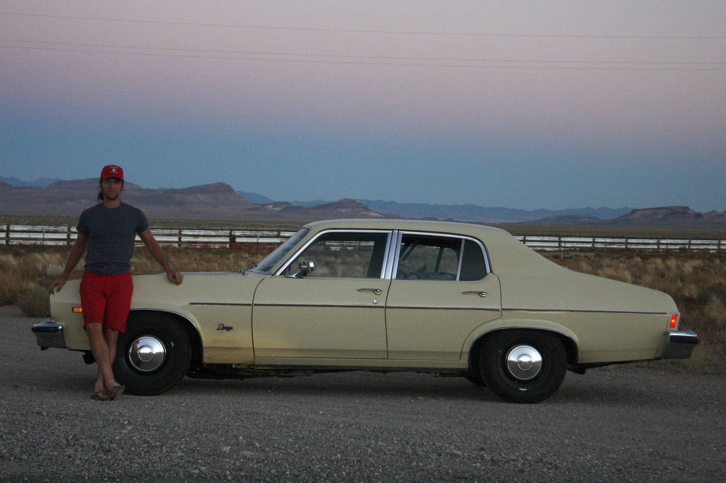
There was plenty of time to think about other things, too. I considered how, even on this deserted road, I felt compelled to drive fast on long straightaways, and wondered why I had a need to drive across the country over and over again at all. But then I looked at the scenery outside the powerful Oldsmobile, considered every minute change each mile brought and realized again the answers to those questions.
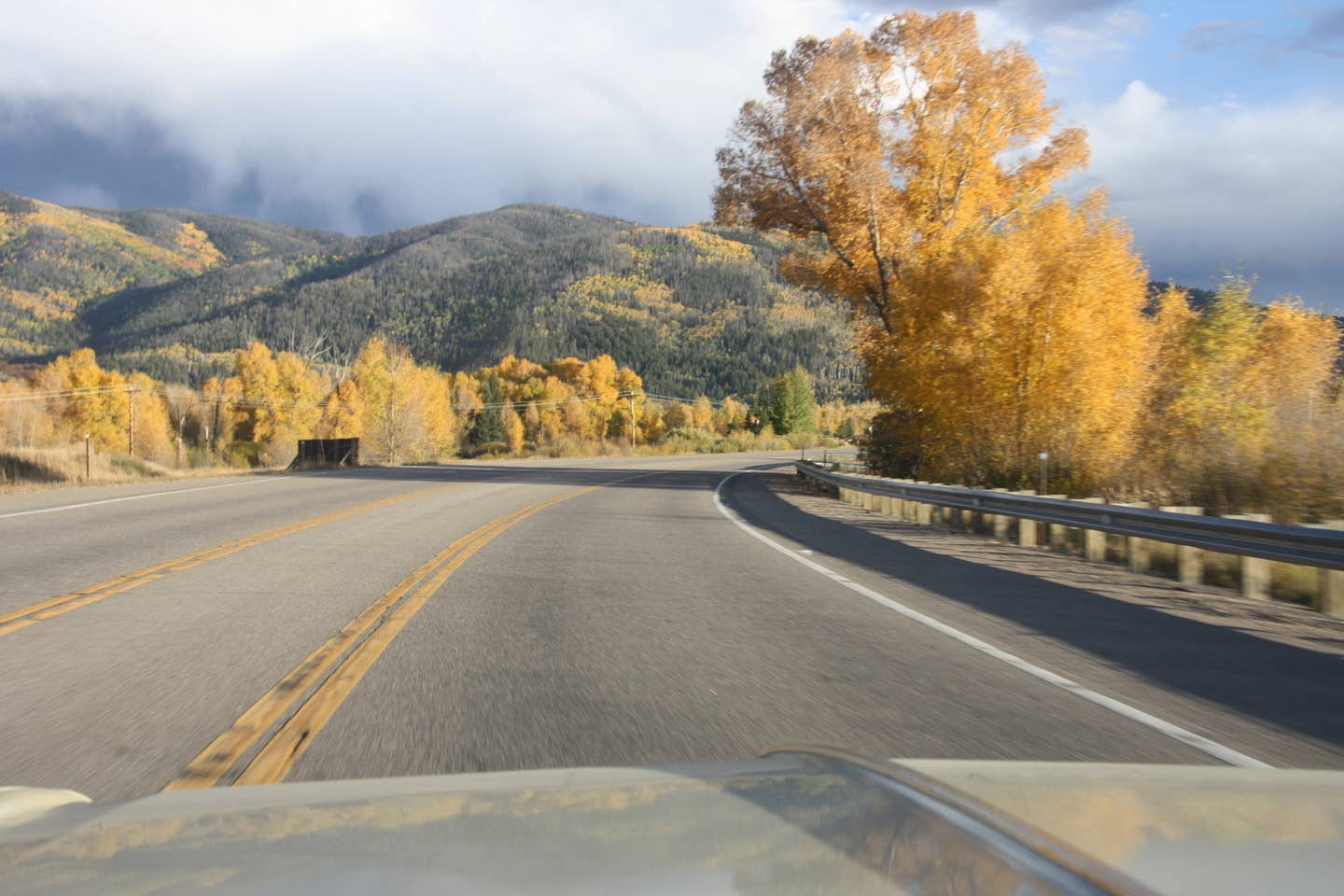
We read to each other, too, finishing Hillbilly Elegy and churning through a few New Yorker articles as the miles ticked away. In eastern Utah and Colorado, the aspens had already begun turning their spectacular shade of bright yellow. This took away our appetite for reading – all we could do was stare.
The two-lane journey ended in Laramie, Wyo. Typing the "avoid highways" option into Google Maps had served us well in our efforts to avoid I-80. But the road between Laramie and Cheyenne had been almost entirely replaced by interstate. At least, when I tried to follow the "avoid highways" path laid out for me by the computer, we ended up driving on a gravel road a few feet from the freeway. The proximity of roaring tractor trailers and the complexity of navigating around interchange cloverleafs took all the fun out of two-lane driving.
We put tires to four-lane for the first time since Paso Robles, Calif., and drove into Nebraska on the interstate. The next day, we made an effort to stay on U.S. highway 30, and did so through most of the Cornhusker state. Clots of pickup trucks and GM sedans coagulated around grain mills along the highway, but we pressed on. We were eager to observe the change from dry west to green east – the official demarkation line is the 100th meridian – on a road that kept us more closely involved with the landscape. Interstate highways, even when they slice across breathtaking terrain, have a way of throwing off the scale the traveler feels in relation to his surroundings.
Eventually, our eastward progress demanded more speed, and we had no choice but to complete the journey like every one else with a schedule to keep – on the interstate. It was a good reminder that having interstate highways is much better than not having them. Since the creation of the system, in 1956, primary highway travel has become a slick, efficient means of getting around and moving goods to market. (We can only hope that our government does what it takes to maintain and improve the system, but that's another story.) Today, there's typically no better way to drive when you need to Get There.
But every now and again, we owe it to ourselves to unplug, close our scheduling books and planners and take a turn off the main highway to soak in the majesty surrounding the path less traveled.